


MS RFC 134: OGC API Support
- Author:
Steve Lime
- Contact:
- Author:
Tom Kralidis
- Contact:
- Author:
Jeff McKenna
- Contact:
- Status:
Adopted
- Last update:
2021-06-30
- Version:
MapServer 8.0
Not
This document is outdated, please follow the official document: OGC API : Features
Overview
OGC is undergoing a revolutionary effort around modernizing their API specifications to align with current technology and design patterns:
REST
JSON
OpenAPI (and Swagger)
The OGC API efforts represent a clean break from the first generation WxS specifications. This RFC is an attempt describe MapServer support for (initially) the OGC API - Features server specifications. The modular nature of OGC API will allow for reuse of shared functionality (landing pages, conformance, collections, queryables, filtering, etc.) across various OGC APIs implemented in MapServer.
OGC API request/response design patterns consist of HTTP operations with GET (KVP) or POST (JSON) methods to specific query parameters. HTTP methods beyond GET/POST (PUT, DELETE, etc.) are envisioned as optional extensions for transactional capability.
Below are mappings between WxS specifications implemented in the MapServer suite and the relevant emerging OGC API standards.
WxS |
OGC API |
|---|---|
OWS Common |
OGC API - Common |
WMS |
OGC API - Maps |
WMTS |
OGC API - Tiles |
WFS |
OGC API - Features |
WCS |
OGC API - Coverages |
SLD |
OGC API - Styles |
Proposed Approach
Much of the underlying functionality needed to support the OGC API specifications already exists in MapServer and is exposed via WxS support. WxS support is complex owing mostly to the various versions of the service specifications that are supported. The code is full of conditionals so things behave differently or expose new functionality depending on version. The WxS specifications rely heavily on query strings (GET/POST) to configure requests and XML for responses.
While there will most certainly be opportunities to leverage portions of the existing OWS/WxS code, it doesn’t make sense to further complicate the main WxS functions. We can also develop the new functionality using C++ and can take advantage of modern C++ libraries such as nlohmann/json and Inja. Working in “clean break” mode also follows the OGC API approach to modernizing the APIs.
CGI/FastCGI Integration
In order to support a RESTful, resource/path-based approach to requests we need to rely on additional CGI components beyond the query string or post-body: specifically information stored in the PATH_INFO environment variable. We also need a mapfile and some indication of what API specification is being used. We propose the following approach:
http(s)://maps.dnr.state.mn.us/cgi-bin/mapserv/mapfile/api/route
Where:
/mapfile/api/route = PATH_INFO
mapfile = the environment variable referencing the full-path mapfile name
api = the API signature (e.g. ogcapi), allowing for support of multiple APIs
route = the API route (e.g. /collections/layer/id)
The PATH_INFO variable is part of the CGI standard and (at least with Apache) is already available to MapServer. In addition, MapServer already supports environment variable-based mapfile definition. It turns out to be relatively simple to check for the presence of PATH_INFO and redirect processing to a API dispatcher if necessary. The standard workflow is largely unaffected by this change so there should be no backwards compatibility issues.
This setup also allows for the query string to be utilized by APIs so you can combine things like so:
http(s)://maps.dnr.state.mn.us/cgi-bin/mapserv/mapfile/ogcapi/conformance?f=html
Configuration
Like the other OGC WxS services, OGC API support will be configured via WEB and LAYER object metadata. A new namespace - oga (OGC Geospatial API) will be recognized and wherever possible OGC API support will leverage existing ows|wfs|wms|gml metadata. The oga namespace will take precedence in metadata lookups.
Also like other OGC WxS services, OGC API support would need to be explicitly enabled using the metadata “oga_enable_request” (or “ows_enable_request”) value at the MAP and LAYER level. Currently all or nothing (“oga_enable_request” “OGCAPI”).
Metadata element naming should mirror API specifications to spare a new implementation from legacy naming conventions. However, WxS metadata should also be referenced as a fallback in order to leverage existing configurations. An example the API description where we would look for oga_description at the MAP level and fallback to ows|wfs_abstract if not found.
New metadata keys (oga namespace):
Key |
Level |
Meaning |
|---|---|---|
onlineresource |
Map |
API root url, can’t reuse WxS values |
html_template_directory |
Map |
full path or relative (to mapfile) of html template directory |
description |
Map |
service description, fall back to ows/wfs_abstract |
links |
Map, Layer |
comma delimited list of link keys - references to other metadata |
link_{key}_title |
Map, Layer |
link title |
link_{key}_href |
Map, Layer |
link href (url) |
html_tags |
Map |
comma delimited list of tag keys to expose to HTML templates - references to other metadata |
tag_{key} |
Map |
value associated with the tag, added to JSON data in template.tags object |
keywords |
Layer |
comma delimited list of keywords, fall back to ows/wfs_keywordlist |
max_limit |
Map, Layer |
map or layer-level maximum limit value (integer) |
JSON Support
OGC API specifications rely heavily on JSON. The excellent nlohmann/json C++ library will be used to construct response objects for each request type. The library is best-of-breed and widely used by other OSGeo projects such as PROJ. More importantly, integration is simple: just include a single .hpp file. I propose actually distributing the nlohmann/json.hpp file with MapServer and then upgrading it as necessary. No complicated cmake configuration is necessary in that case.
nlohmann/json has a MIT license.
HTML Support
While not required, HTML support is strongly encouraged. Instead of somehow trying to store and output HTML from inside MapServer, I propose using a series of templates to support HTML responses. This gives us (and users) a great deal of flexibility to control the look and feel of API documentation. Base OGC API templates would be shipped with MapServer and are constructed using Bootstrap 4 by default. A second set of plain HTML templates will also be provided and will provide a stable base for msautotest support. The templates live in the MapServer distribution in a new share directory and are organized by API signature (so share/ogcapi/templates). All a user needs to do to configure HTML responses is to note the base path of the templates as a metadata value (oga_html_template_directory) or environment variable (OGCAPI_HTML_TEMPLATE_DIRECTORY).
The C++ Inja templating library is used to process HTML responses. Inja depends on nlohman/json so API responses will always be composed first in JSON and then rendered as HTML using Inja. Inja is full-featured and supports expressions, conditionals, loops and includes, amongst other things. Like nlohmann/json, Inja is easy to integrate using a single .hpp file. Again I propose distributing Inja with MapServer.
Inja also has a MIT license.
MapScript Support
For consideration: should the SWIG MapScript class OWSRequest be enhanced to also allow to dynamically modify OGC API services?
New Source Files
- mapogcapi.cpp/mapogcapi.h:
core implementation.
- third-party/include_nlohmann_json.hpp:
wrapper for nhlohmann/json library.
- third-party/include_pantor_inja.hpp:
wrapper for Inja library.
Not
will need to edit to reference the local instance of nlohmann/json.
Source Files Changed
- mapserv.c/mapserv.h:
add call to msCGIIsAPIRequest() to main CGI workflow. Added function prototypes for msIsAPIRequest() and msCGIDispatchAPIRequest(). Added command-line hook to set PATH_INFO.
- mapservutil.c:
add msIsAPIRequest() and msCGIDispatchAPIRequest() functions. Update msCGILoadMap() to load a mapfile defined by API - basically the environment variable use case.
- cgiutil.c:
updated to use msSetError() rather than writing error messages directly. Extend cgiRequestObj init/free functions as appropriate.
- cgiutil.h:
add path_info, api_path and api_path_length attributes to cgiRequestObj.
- maperror.c/maperror.h:
added OGC API support to msGetVersion(). Added new API error code and error message. Note that specific OGC API error handling is handled locally within mapogcapi.cpp.
Build Files Changed
- CMakeLists.txt:
typical integration of new functionality.
- mapserver-config.h.in:
added USE_OGCAPI_SVR.
Limitations/Caveats
Input/output SRS are EPSG:4326 only.
Feature properties support GML item and constant configuration. Groups are not implemented.
Backwards Compatibility Issues
None anticipated - new functionality.
Security Considerations
API Route Handling
Most complex route:
/{mapfile}/ogcapi/collection/{collectionId}/item/{itemId}
Fixed API route elements must match precisely and are case sensitive. Any deviation will result in error.
Variable API route elements are handled as follows:
- {mapfile}:
references a mapfile defined in the environment. If the mapfile is not found a standard CGI error message is returned.
- {collectionId}:
references layer name and must match exactly. If the layer is not found or if the layer is not eligible (e.g. raster) a 404 error is thrown (as JSON).
- {itemId}:
references a feature ID as defined by gml_featureid metadata. Optionally the value is validated using a regex supplied in the layer validation block. If the validation fails a 404 error is thrown (as JSON). (the namepaces oga, ows, and wfs are also checked, such as oga_featureid)
METADATA
  "gml_featureid" "myid"
  ...
END
VALIDATION
  "myid" "^[0-9]{2}$" # limit to 2-digit integers
  ...
END
Not
We could consider extending validation like this to OGC services that accept filters._
Parameter Handling
Relatively few parameters are supported in this initial implementation:
- f:
format of the response, supported values are json and html. Error is return with any other value. Default is html.
- bbox:
bounding box filter. Error is returned with malformed values, more/less than 4 numbers, degenerate bounds or if values are not given in lat/lon. Default is the map’s default extent is used.
- limit:
number of results to return. Error is returned with malformed value. Other values are clipped to the range 1 to 10,000 (per spec).
- start:
page number. Error is returned with a malformed value.
Template Handling
Templates contain Inja template markup. The filenames are fixed in code (e.g. collection-items.html). The directory containing the templates is given in webObj metadata or (optionally) via environment variable. The directory specification is either absolute (e.g. /opt/mapserver/ogcapi/templates) or relative to the location of the mapfile. As present the implementation allows the use of the Inja {{ include “file” }} tag. It’s really impractical to maintain templates with common elements (e.g. header, footer, etc…) without that functionality. The current Inja implementation allows any value for the file attribute which represents a security risk if access to the templates is not limited. There are existing enhancement requests for Inja to add this functionality, or we’ll need to update the library to limit includes to the specified directory or sub-directories.
Large Dataset Handling
It is not clear how large of datasets can be handled via nlohmann/json and/or Inja (see above). The default maximum limit value of 10,000 may not be appropriate in many cases. It is possible to set a map and/or layer limit using oga_max_limit metadata. The layer value takes precedence. Paging is available for drivers the support it, leveraging the work done for WFS.
Performance Implications
There should be very little overall performance impact. A single function is added to the mapserv.c workflow to detect an API request. The function inspects the PATH_INFO environment variable to see if the value (if any) matches the minimum pattern for an API call as described earlier. If so, elements in the cgiRequestObj are set and the request is quickly pushed into the OGC API processing workflow once a mapfile is loaded.
Ticket ID and References
Voting history
+1 from SteveL, JeffM, TomK, EvenR, JukkaR, JeromeB, MikeS, SethG
Current Status
Support |
Status |
|---|---|
Features: Landing page |
🚧 |
Features: JSON & HTML output |
✅ |
Features: Collections (layer listing) |
🚧 |
Features: Collections (single layer: links (summary) |
🚧 |
Features: Collections (single layer: query) |
🚧 |
Features: Collections (single layer: list queryable fields) |
❌ |
Features: Collections (single layer: map) |
❌ |
Features: API docs |
❌ |
Features: msautotests |
🚧 |
Features: user docs on mapserver.org |
❌ |
Issues / Tasks / Wishlist
- issue:
cleaning the onlineresource of “?” or “/” ending characters, as it causes problems in HTML landing pages (double-slashes in links, or the “?” will actually break all links)
- issue:
compile fails without enabling -DUSE_WFS_SVR (as well as the obvious -DUSE_OGCAPI_SVR)
- task:
add ows_contact* information to the landing page (from the associated values set in the mapfile)
- wishlist:
besides the “/ogcapi” API signature (for features, maps..support), also allow “/features” (to allow developers to only request vector collections), for example:
http://127.0.0.1/cgi-bin/mapserv.exe/demo-ogcapi/features
(Note that is how the GeoServer implementation works)
- wishlist:
include MapServer logo on landing page
- wishlist:
set MapServer favicon for all HTML pages
- wishlist:
allow other link types for collection item (set through mimetype/outputformats in mapfile?)
- wishlist:
instead of text links, use a dropdown for types (JSON, HTML, KML, etc.)
- wishlist:
for the single layer map, include a dropdown to set the default number of features displayed in the map:
10 [default]
100
1000
- wishlist:
for the single layer map, display the current MapServer scale value below the map (as user zooms in, update the scale with the CGI [scale] value)
Initial Screencaptures
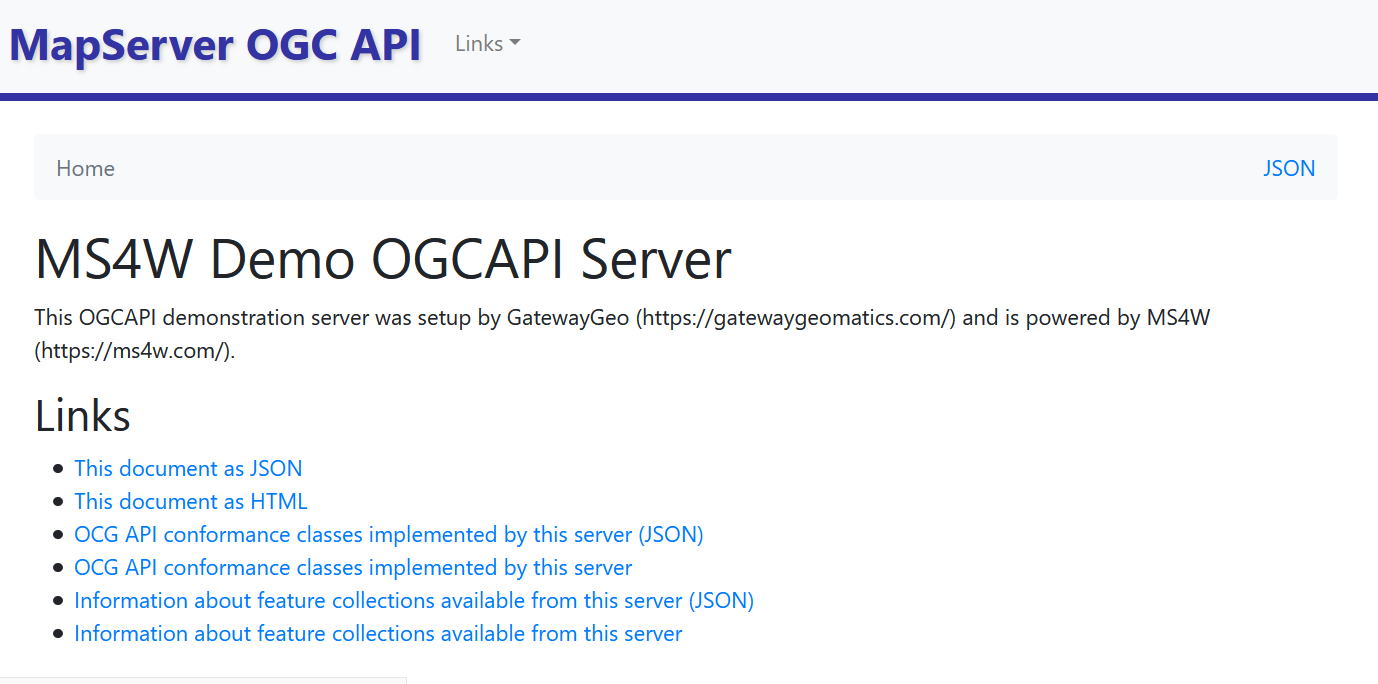
Landing Page
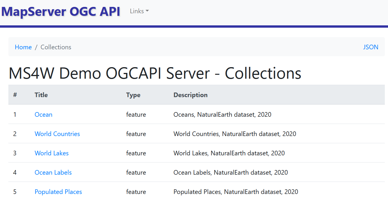
Collections
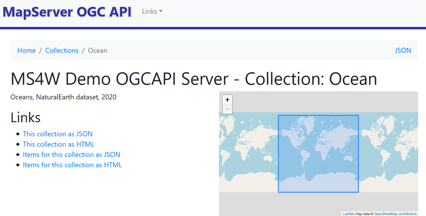
Collection