


GeoJSON
- Author:
Jeff McKenna
- Contact:
jmckenna at gatewaygeomatics.com
- Last Updated:
2021-09-15
GeoJSON is a text-based, open standard format that can represent vector points, lines, polygons, and multi-part collections. Officially, it is a geospatial data interchange format based on JavaScript Object Notation (JSON). GeoJSON is a specification as part of the Internet Engineering Task Force (IETF).
More Information
More information about GeoJSON is available at:
Official page: https://geojson.org/
Specification: https://datatracker.ietf.org/doc/html/rfc7946
File listing
GeoJSON files are usually a single text file with a JSON filename extension, such as:
countries.json
You can open that file in a text editor, and it will look something like:
{
    "type": "FeatureCollection",
    "name": "countries",
    "crs": { "type": "name", "properties": { "name": "urn:ogc:def:crs:OGC:1.3:CRS84" } },
    "features": [
    { "type": "Feature", "properties": { "name_en": "Fiji" }, "geometry": { "type": "MultiPolygon", "coordinates": [ [ [ [ 180.0, -16.067132663642447 ], [clipped for display here...], [ -179.793320109048636, -16.020882256741224 ] ] ] ] } },
    { "type": "Feature", "properties": { "name_en": "Tanzania" }, "geometry": { "type": "MultiPolygon", "coordinates": [ [ [ [ 33.903711197104528, -0.95 ], [ 34.07262, -1.05982 ], [clipped for display here...], [ 33.903711197104528, -0.95 ] ] ] ] } },
    ...
    ]
}
Tip
You can also drag and drop your GeoJSON file into a modern web browser, such as FireFox, and it will nicely display your file.
Note
Windows users who want to follow along, can convert MS4W’s included demo.db SpatiaLite database into a GeoJSON file (for the countries table) with the command (executed inside /ms4w/apps/local-demo/data/) :
ogr2ogr -f GeoJSON countries.json demo.db countries
Data Access / Connection Method
GeoJSON access is available in MapServer through OGR’s GeoJSON driver.
The CONNECTIONTYPE OGR parameter must be used.
The path to the GeoJSON file is required, including the file extension.
CONNECTIONTYPE OGR
CONNECTION "name.json"
DATA "layername"
Step 1: Use ogrinfo to examine
Using ogrinfo on the GeoJSON file:
> ogrinfo countries.json

INFO: Open of `countries.json'
      using driver `GeoJSON' successful.
1: countries (Multi Polygon)
Using ogrinfo to examine the structure of the countries layer:
> ogrinfo countries.json countries -summary

INFO: Open of `countries.json'
      using driver `GeoJSON' successful.

Layer name: countries
Geometry: Multi Polygon
Feature Count: 177
Extent: (-180.000000, -90.000000) - (180.000000, 83.645130)
Layer SRS WKT:
GEOGCS["WGS 84",
    DATUM["WGS_1984",
        SPHEROID["WGS 84",6378137,298.257223563,
            AUTHORITY["EPSG","7030"]],
        AUTHORITY["EPSG","6326"]],
    PRIMEM["Greenwich",0,
        AUTHORITY["EPSG","8901"]],
    UNIT["degree",0.0174532925199433,
        AUTHORITY["EPSG","9122"]],
    AUTHORITY["EPSG","4326"]]
featurecla: String (0.0)
scalerank: Integer (0.0)
labelrank: Integer (0.0)
sovereignt: String (0.0)
sov_a3: String (0.0)
adm0_dif: Integer (0.0)
level: Integer (0.0)
type: String (0.0)
admin: String (0.0)
adm0_a3: String (0.0)
...
Step 2: Add the layer in your mapfile
For OGR connections, it is always recommended to set CONNECTIONTYPE, CONNECTION, and DATA, as follows:
/* Countries */
LAYER
  NAME "countries"
  TYPE POLYGON
  STATUS ON
  CONNECTIONTYPE OGR
  CONNECTION "countries.json"
  DATA "countries"              # the OGR layername, found through ogrinfo
  CLASS
    NAME "World Countries"
    STYLE
      COLOR 200 200 200
      OUTLINECOLOR 0 0 0
      WIDTH 0.1
    END #style
  END #class
END #layer
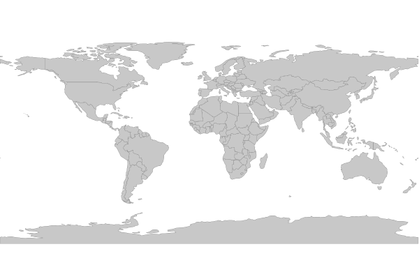
Step 3: Test your Mapfile with map2img
Use the MapServer commandline utility map2img to verify that your mapfile creates a valid map image, and also display draw times, such as:
map2img -m geojson.map -o ttt.png -map_debug 3

msDrawMap(): rendering using outputformat named png (AGG/PNG).
msDrawMap(): WMS/WFS set-up and query, 0.000s
msDrawMap(): Layer 0 (countries), 0.091s
msDrawMap(): Drawing Label Cache, 0.000s
msDrawMap() total time: 0.091s
msSaveImage(ttt.png) total time: 0.007s
Tip
MS4W users will notice that the demo mapfile that is part of every installation (at /ms4w/apps/local-demo/local.map) is configured to output GeoJSON.